|
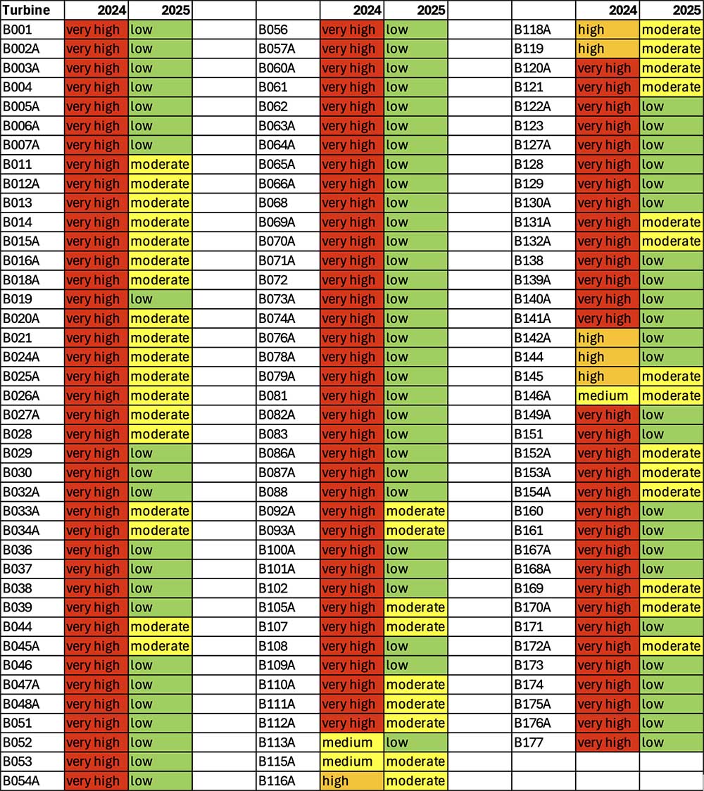
1. How can Winterbourne Wind and ERM justify the change in method of measuring the turbine risk rating, resulting in vastly different risk rating outcomes? It appears the new method has been adopted purely to get a more favourable outcome for the developer. Are DCCEEW – BCS going to accept this assessment? Is this risk rating for birds and bats or only for bats?
(See Appendix A)
2. There are areas within the World Heritage Area and Wilderness Areas where 100-119 turbines are visible, including areas on the Green Gully Track. These will intrude above the horizon. There are also areas within the World Heritage Area less than 2km from turbines. Will the night lights on the turbines be visible from these areas?
3. Table E-4 shows change in impacts through project amendments/BDAR Revisions. Most of these “improvements” appear to be due to reclassification of vegetation communities and using higher resolution mapping, rather than a change in project design. Will DCCEEW-BCS be scrutinising these changes?
4. The amended BDAR states that the CRM model indicates that between two and ten birds are estimated to collide with project WTG’s every year. It states that this equates to between 23 and 113 collisions over the operational life of the project. If the project is operational for 25 years, it should equate to between 50 and 250 birds. Is this lower number a result of less birds due to reduced habitat, bird deaths and barrier effects, or is it an error?
5. Have the DPHI considered that the original site location of this project is inappropriate (based on section 7.1 of the Biodiversity Assessment Model), and this has resulted in a project with unacceptable environmental impacts despite attempts of design modification? There are many locations within the NE REZ that are not adjacent to the National Park and World Heritage Area. The impacts on the World Heritage Area and areas of high biodiversity value as well as disruption to important biodiversity corridors can be avoided by correct early site location. These impacts can not be minimised or mitigated to acceptable levels. Has the developer considered locations that do not have such high biodiversity impacts, impacts on World Heritage Areas, community impacts, and impacts on aerial firefighting?
6. How do DPHI measure social license? The submissions report highlights that host landowners who have a significant financial interest in the project can put in multiple submissions under different names, entities and companies – essentially the same person. There are also examples of people, who live overseas, putting in incorrect addresses, so their submission is counted as a local submission. There are a large number of submissions from remote locations that are a clear demonstration of the developers attempts to rally supporting submissions. It is clear from the number of local objections that this project will have significant impacts on the local community and the project does not have social license.
7. Given the high number of birds in the region and the high number of birds in the CRM, can bird detection/automated curtailment systems be installed on all WTGs if the project is approved? The significant impact threshold for White throated needletail is 41 birds and the fork-tailed swift is 50 birds. Is this an acceptable level?
8. How will aerial firefighting in the vicinity of the project, particularly given the proximity to the National Park, be impacted? The proponent has said that wind turbines will be assessed as potential hazards to aircraft operations and operations would be altered as necessary. This does not explain how this will impact the ability and timing for aerial firefighters to respond in emergencies. How long will aircraft be delayed from fire-bombing houses in the event of a bushfire? Operators have reported that they will simply not fly in the project area, and so the route from water collection at Walcha Airport to fire prone sites in the National Park will incur a significant detour and time delay.
9. WWF have indicated in their decommissioning report that the most likely method of decommissioning is by demolition rather than deconstruction. Given the proximity to the World Heritage Area, if the project is recommended for approval, will the DPHI consider that the terms of consent will include decommissioning to be by deconstruction to avoid contamination of this sensitive area?
10. Vestas have said that blades will shed up to 50g per blade per year and continue to say that this is only a very small amount (0.001% of the blade). However, with 118 turbines, over 30 years, this amounts to 531kg of toxic material, containing Bisphenol A, that will be shed into the World Heritage and wilderness area. Will Winterbourne be monitoring before and after project contamination levels of contaminants, including bisphenol A? Is there a management plan for this? Combined with the contamination from decommissioning, is this project too poorly located to be approved?
11. Winterbourne Wind Farm are intending to build/modify roads that are not to Austroads standards in the Walcha LGA. Is this appropriate? Will the local Council be left to deal with substandard roads post-construction?
|